

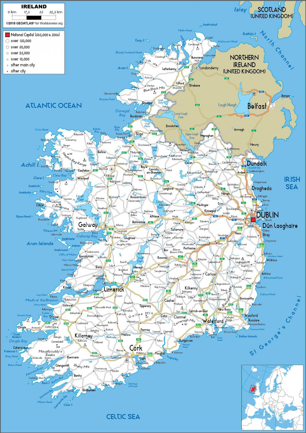
You can find on this page the Ireland road map to print and to download in PDF. The Ireland driving map presents the detailed road network, main highways and free motorways of Ireland in Northern Europe.
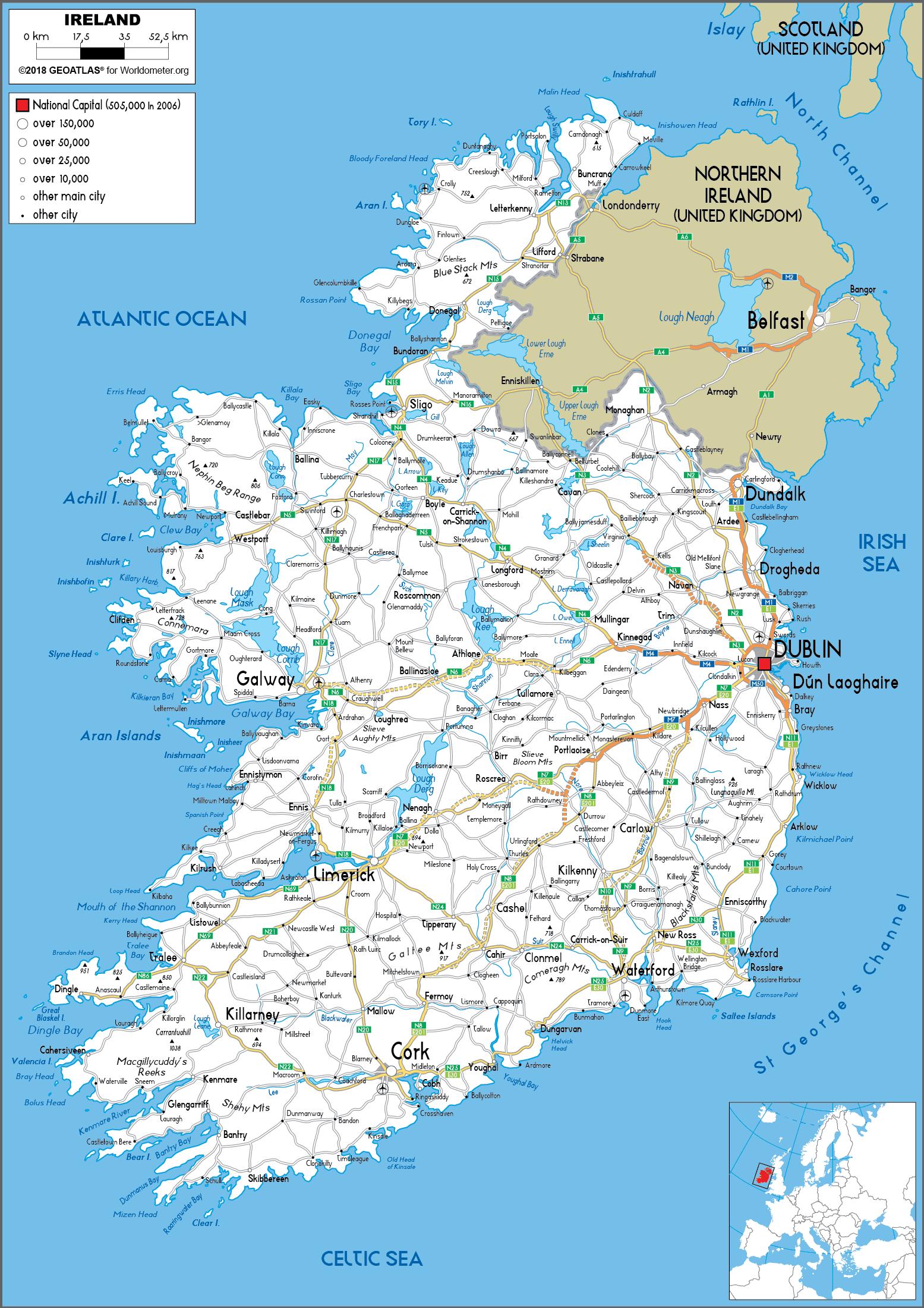
The Ireland road map shows all roads network and main roads of Ireland. This road map of Ireland will allow you to preparing your routes and find your routes through the roads of Ireland in Northern Europe. The Ireland roads map is downloadable in PDF, printable and free.
The major differences between roads in Northern Ireland and the Republic of Ireland are in road quality and route classification, signposts and speed limits. Roads in Northern Ireland are classified as either motorways (shown by the letter M followed by a route number, e.g. M1), A-roads (shown by the letter A followed by a route number, e.g. A6), B-roads (shown by the letter B followed by a route number, e.g. B135) and other roads as you can see in Ireland roads map. There are two types of A-roads: primary and non-primary. Roads in the Republic are classified as either motorways (shown by the letter M followed by a route number, e.g. M7), National roads (shown by the letter N followed by a route number, e.g. N25), Regional roads (shown by the letter R followed by a route number, e.g. R611) and Local roads (shown by the letter L followed by a route number, e.g. L4202). There are two types of National roads: National Primary routes and National Secondary routes.
All public roads which are not motorways, national roads or regional roads are local roads as its shown in Ireland roads map: "a public road, other than a national road or a regional road, shall be a local road". Local roads vary greatly in quality, from wide urban streets to very narrow, rural lanes, known as boreens in Ireland. There are three types of Local Road: Local Primary (local roads wider than 4 metres), Local Secondary (local roads narrower than 4 metres) and Local Tertiary (cul-de-sacs and other minor roads). Local roads are subject to a general speed limit of 80 km/h (imperial equivalent: 50 mph) or 50 km/h (imperial equivalent: 31.25 mph) in built-up areas. Local roads are not generally referred to by number, but are registered with a four- or five-digit "L" number, taking the form Lxxxx.
The Republic has an extensive network of public roads connecting all parts of the country. As of 31 December 2007, there was a total of 5,427.58 km of national roads: 2,743.606 km of national primary routes (including motorways) and 2,683.974 km of national secondary routes as its mentioned in Ireland roads map. In addition to national roads, the Republic also has an extensive network of other public roads: there are 11,630 kilometres of regional roads and 78,972 kilometres of local roads. The main roads in Northern Ireland, which connect well with those in the south, are classified "M"/"A"/"B" as in Great Britain. Whereas the roads in Great Britain are numbered according to a zonal system, there is no available explanation for the allocation of road numbers in Northern Ireland, though their numbering is separate from the system in England, Scotland and Wales.
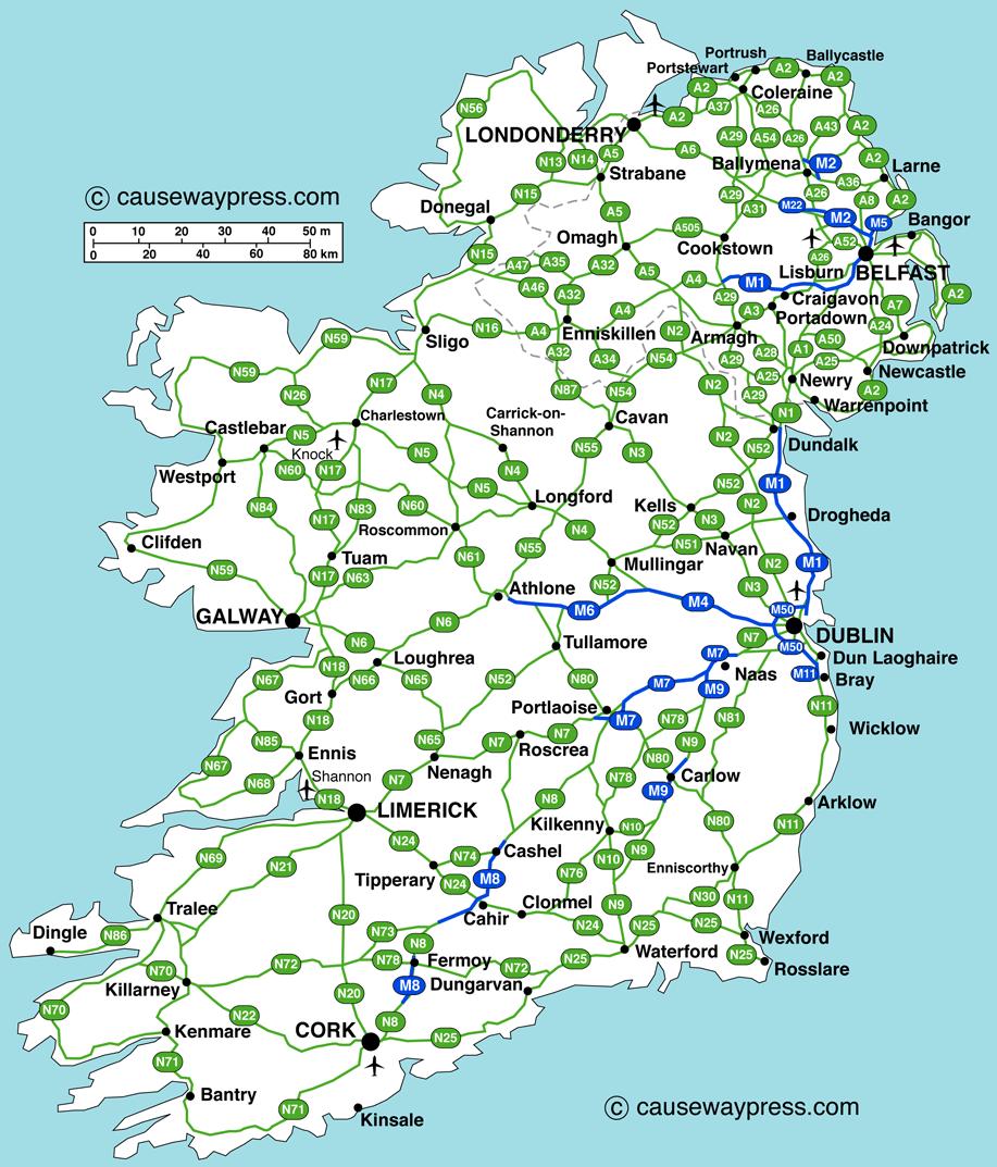
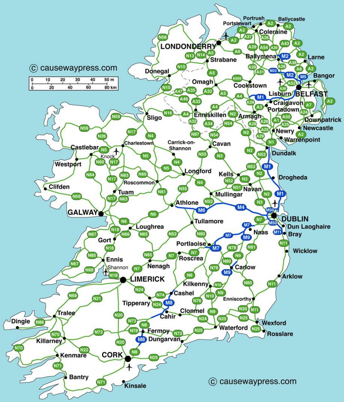
The Ireland highway map shows toll and free motorways of Ireland. This highways map of Ireland will allow you to prepare your routes on motorways of Ireland in Northern Europe. The Ireland highway map is downloadable in PDF, printable and free.
In the Republic of Ireland, the highest category of road is a highway, indicated by the prefix M followed by one or two digits as you can see in Ireland highway map. The motorway network has been expanded extensively since the 1990s, through construction of new motorways and redesignation of existing motorway-standard dual-carriageway sections of National Primary routes. The first motorway section in the state was the M7 Naas by-pass, which opened in 1983. As of 2009, all motorways in Ireland are part of, or form, national primary roads. At the end of 2004 there were 192 km (119 mi) of motorway in the Republic and 286 km (178 mi) of dual-carriageway. This was extended, by the end of 2005, to 247 km (153 mi) of motorway and 297 km (185 mi) of dual-carriageway. By the end of December 2009 there were 667 km (414 mi) of motorway in Ireland, with 385 kilometres (239 mi) under construction.
In June 2007, it was announced that around 800 kilometres of 'new' highway would be created; however, much of this resulted from the re-classification of most of the country high-quality dual carriageways to motorway regulations rather than the construction of purpose-built motorways as its shown in Ireland highway map. This has affected most of the major inter-urban routes between Dublin and various towns and cities and some of the Atlantic Corridor along the Western seaboard. In December 2007, it was announced that a planned high quality dual carriageway scheme between Galway and Tuam would be built as a motorway, the first such new motorway project to be announced since the early 2000s.
Another new motorway, the M20, is being planned as the main route between Cork and Limerick. By 2015, the NRA planned that there would be approximately 1090 km of motorway in Ireland, comprising the M50 (49 km), M20 (90 km approx), M18 (70 km approx), M32(600m)M17 (25.5 km), M11 (62 km), M9 (116.5 km), M8 (143 km), M7 (185 km), M6 (144 km), M4 (62 km), M3 (57 km), M2 (13 km), and M1 (83 km) as its mentioned in Ireland highway map. However the Irish financial crisis has brought this target into question. On 30 September 2008 (see below), it was announced that the proposed 26.6 km Gort to Oranmore scheme was to be included in the second tranche of motorway re-designations as it will link into the proposed M17.