

You can find on this page the Ireland trains map to print and to download in PDF. The Ireland railways map presents the rail network and shows high speed rails routes of Ireland in Northern Europe.
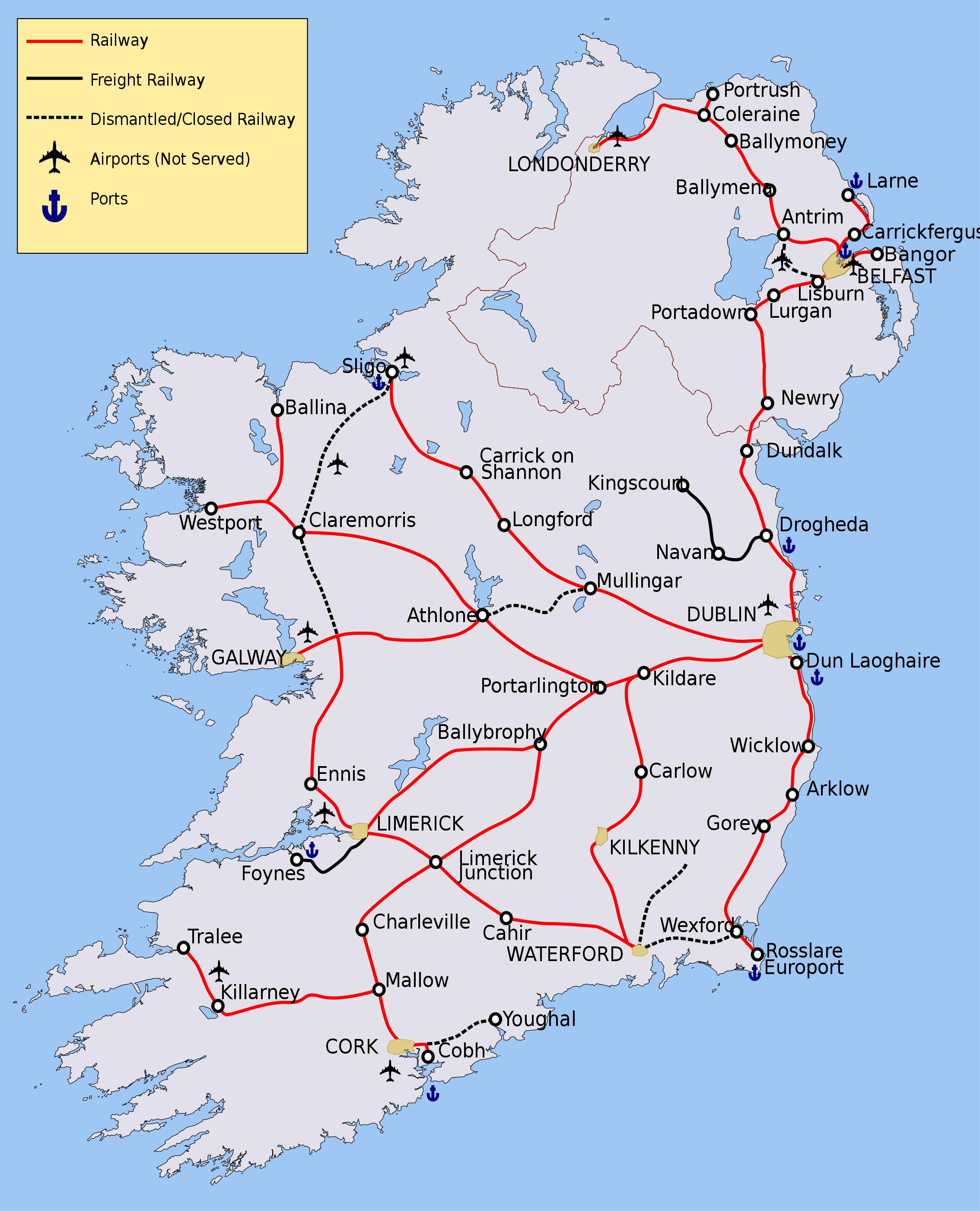
The Ireland rail map shows all the railway stations and lines of Ireland trains. This train map of Ireland will allow you to easily travel by train in showing the major rail routes and high speed rail routes of Ireland in Northern Europe. The Ireland rail map is downloadable in PDF, printable and free.
Ireland railways are in State ownership, with Iarnród Éireann (Irish Rail) operating services in the Republic and NI Railways operating services in Northern Ireland. The two companies co-operate in providing the joint Enterprise service between Dublin and Belfast as you can see in Ireland rail map. InterCity services are provided between Dublin and the major towns and cities of the Republic, and in Ulster along the Belfast–Derry railway line. Suburban railway networks operate in Dublin, Dublin Suburban Rail, and Belfast, Belfast Suburban Rail, with limited local services being offered in, or planned for, Cork, Limerick, and Galway. The rail network in Ireland was developed by various private companies during the 19th century, with some receiving government funding. The network reached its greatest extent by 1920. A broad gauge of 1600mm (5 ft 3in) was agreed as the standard for the island, although there were also hundreds of kilometres of 914mm (3 ft) narrow gauge railways.
Many Ireland rail lines in the west were decommissioned in the 1930s under Éamon de Valera, with a further large cull in services by both CIÉ and the Ulster Transport Authority (UTA) during the 1960s, leaving few working lines in the northern third of the island as its shown in Ireland rail map. There is a campaign to bring some closed lines back into service, in particular the Limerick-Sligo line (the Western Railway Corridor), to facilitate economic regeneration in the west, which has lagged behind the rest of the country. There is also a move to restore service on the Dublin to Navan line, and smaller campaigns to re-establish the rail links between Sligo and Enniskillen/Omagh/Derry and Mullingar and Athlone/Galway. Under the Irish government Transport 21 plan, the Cork to Midleton rail link was reopened in 2009. The re-opening of the Navan-Clonsilla rail link and the Western Rail Corridor are amongst future projects as part of the same plan. Public transport services in Northern Ireland are sparse in comparison with those of the rest of Ireland or Great Britain.
A large railway network was severely curtailed in the 1950s and 1960s. Current services includes suburban routes to Larne, Newry and Bangor, as well as services to Derry. There is also a branch from Coleraine to Portrush. Since 1984 an electrically operated train service run by Iarnród Éireann has linked Dublin with its coastal suburbs as its mentioned in Ireland rail map. Running initially between Bray and Howth, the Dublin Area Rapid Transit (DART) system was extended from Bray to Greystones in 2000 and further extended from Howth Junction to Malahide. In 2004 a light rail system, Luas, was opened in Dublin serving the central and western suburbs, run by Veolia under franchise from the Railway Procurement Agency. The construction of the Luas system caused much disruption in Dublin. Plans to construct a Dublin Metro service including underground lines were mooted in 2001, but stalled in the financial crisis at the end of that decade. Ireland has one of the largest dedicated freight railways in Europe, operated by Bord na Móna totalling nearly 1,400 kilometres (870 mi).